|
|
|
|
|
|
|
|
|
|
|

GALLERY
OF DESIGNS — click
a thumbnail for a larger version
Streets
![]()
![]()
![]()
![]()
![]()
![]()
![]()
![]()
![]()
![]()
![]()
![]()
![]()
![]()
![]()
![]()
|
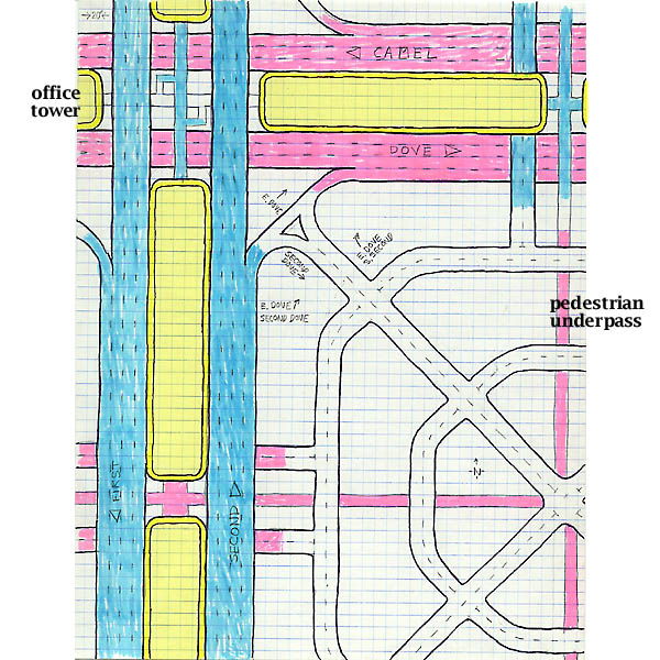
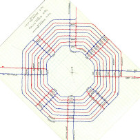
Here's a city with only two ranks of roadway: expressways and streets. Roadways shown in blue are elevated ten feet above the general terrain, while pink ones are depressed ten feet below. The intersection at the upper left involves four one-way expressways: southbound First and northbound Second in blue, and westbound Camel and eastbound Dove in pink. This intersection is essentially the crossing of two freeways. In the "medians" of the "freeways," each yellow block is an office tower with a garage on the lower few levels. Traveling north on Second, you can turn right onto Dove by means of a descending ramp. (However, to make a left turn onto Camel, you'd have to drive a block farther and then go around the block by making three rights.) Alternatively, partway down that descending ramp from Second you can make a sharper right turn into the small local street system consisting of an X superimposed onto two octagonal rings.
(TEXT
CONTINUED BELOW) From the outer ring, ascending or descending ramps lead drivers across the expressway lanes to the garages of each of the eight surrounding office towers. Pedestrians on the pink level can pass under all the roadways and access the towers, except at the top of the drawing, where they must climb to the blue level to pass over the Camel/Dove "freeway." |