![]()
![]()
![]()
![]()
![]()
![]()
![]()
![]()
![]()
![]()
![]()
![]()
![]()
![]()
![]()
![]()
Saltsburg
Written
September 2016
|
I have no animosity towards this man, but I must tell you he was literally a leech. David Leech, to be precise. He was a civil engineer who arrived in 1827 at a bend in the Kiskiminetas River in western Pennsylvania, where he settled on land he bought from a Native American chief named White Mattock. The place became known as Leechburg. There Leech built a dam for the Pennsylvania Main Line Canal, about which I’ve written elsewhere. |
|
|
|
Promoters and builders of the canal established headquarters in Leechburg, and several canal shipping companies operated out of the town’s docks and boatyards in the 1830s. |

Off
to the southeast, five hours away by canal boat, there’s
another borough: a former salt-manufacturing town appropriately
named Saltsburg. In 1856, it looked like the drawing
below. The river flows across the bottom of the picture, and
the canal cuts across the middle. The arrow-like feature is a
lock, into which water from upstream could be admitted to raise a
boat eight feet before it continued on under the non-covered bridge
towards Johnstown and the distant mountains.


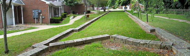
The
recent Google Earth view is from about the same angle as the
160-year-old sketch above it. You can still see the outline of
the lock on the left, and a meandering pedestrian pavement traces the
path of the canal as it crosses Saltsburg’s Washington Street.
|
Earlier this year I stopped by the borough for a visit with my camera. There’s the swirly pavement on the right. Below we see the stone blocks outlining the lock. |
|

|
Constructed in 1828, it originally was about 12 feet deep. Its 15-by-90-foot chamber could accommodate a 14-by-80-foot packet boat. This was Lock #8 on the Kiski-Conemaugh Line from the Allegheny River to Blairsville. A schedule was helpfully provided by D. Leech & Co., Proprietors. From here to Johnstown was 47 miles and could be navigated in 15 hours at three miles per hour (the walking speed of the mule drivers). In the opposite direction, it was 21 miles back to Leechburg and an additional 14 miles to Tarentum, near my present domicile. |
|

From Tarentum on to Pittsburgh was another 21 miles. In an oddity, that last stretch required only 5 hours 35 minutes for boats traveling westward, but 7 hours 45 minutes eastbound. Today we’d blame this discrepancy on evening rush-hour traffic leaving the city on Route 28. I’m not sure what their excuse was in the 19th century.
|
|
|
