|
|
|
|
|
|
|
|
|
|
|
|
|
|
|
|
|
|
|
|
|
|
|
|
|
|
|
|


GALLERY
OF PHOTOS — click
a thumbnail for a larger version
Twin Gables
![]()
![]()
![]()
![]()
![]()
![]()
![]()
![]()
![]()
![]()
![]()
![]()
![]()
![]()
![]()
![]()
|
Here's a 2003 overview of the village. We're looking due west from a virtual helicopter hovering 600 feet above the back lot of the Parrott Implement Company. Converging on Richwood are Ottawa Street on the left and Blagrove Street on the right. The yellow arrow points to the white-roofed Chevrolet dealership that my father built in 1964.
(TEXT
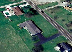
CONTINUED BELOW) In the center of this picture, just beyond the remnants of Memorial Field where Richwood High School athletes once competed, is my old high school building (now the North Union Middle School). On the left edge of the picture is my old elementary school (demolished in 2005). In the bottom right corner is our house, Twin Gables, its black shingles faded to dark gray. A car is parked on the T-shaped blacktop driveway outside the garage.
|